Garbage Patch

December 17, 2025

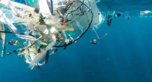
When I opened my MSN browser this morning I found an article on life flourishing in the open ocean.  This is a mix of natural, surface-dwelling ocean creatures and resilient coastal species that use floating plastic as rafts to colonize the open sea, forming new (artificial) ecosystems even as they face dangers from entanglement, plastic ingestion, and toxic contamination.  This biological hotspot is also an ecological nightmare as the plastics disrupt feeding, growth, and development of other marine animals.  Life on the plastics includes coastal species like barnacles (subphylum Crustacea), bryozoans (Phylum Bryozoa), anemones (class Anthozoa), and crustaceans (Subphylum Crustacea) that were carried from home by currents from the 2011 Japan tsunami.  Open-Ocean species like violet snails (Janthina exigua) and blue button jellies (Phylum Ctenophora) also thrive using floating plastic for shelter and feeding.  The non-biodegradable plastics allow these diverse communities to form and even reproduce, bringing life to the Great Pacific Garbage Patch

When I went online, I found the Great Pacific Garbage Patch, or Pacific trash vortex, is a spiral (gyre) of marine debris particles in the central North Pacific Ocean.  The patch is located roughly from 135°W to 155°W and 35°N to 42°N and originates from the Pacific Rim, including countries in Asia, North America, and South America.  Despite the common perception of the patch as giant islands of floating garbage, it is of low density (4 particles per 3.1 yd2 or 1 m2) which prevents its detection by satellite imagery or boaters or divers in the area.  The patch is a widely dispersed area consisting primarily of suspended “fingernail-sized or smaller” (often microscopic) particles (microplastics) in the upper water column.  Researchers from The Ocean Cleanup project claimed the patch covers 620,000 square miles (1.6 million km2) and consists of 50,000 to 142,000 tons (45,000 to129,000 metric tons) of plastic as of 2018 and has grown to twice the size of Texas.  By 2024, the group had removed more than 1 million pounds (453592 kg) of trash from the Patch.

Rehabilitating the Garbage Patch poses a significant challenge due to its immense size and location far from any country’s coastline, making it difficult for any nation to bear the financial responsibility for cleanup.  Various international organizations have pledged to stop the growth of the Garbage Patch.  Charles Moore (who initially uncovered the patch in 1997) is actively involved in raising awareness through the Algalita Marine Research Foundation.  The Ocean Cleanup, led by Boyan Slat, aims to eliminate 90% of ocean plastic pollution by 2040.  The organization is developing technology to extract plastic from the oceans and intercept it in rivers before it reaches the sea.  Their approach is to concentrate the plastic in “artificial coastlines” before collecting and removing it with a long U-shaped barrier that directs the plastic towards a retention zone.  The group’s collection exceeds hundreds of tons (90+ metric tons) and continues to grow.  While microplastics dominate the patch, 92% of the mass consists of larger objects like plastic lighters, toothbrushes, water bottles, pens, baby bottles, cell phones, and plastic bags.  The patch contains around 6 pounds (2.7 kg) of plastic for every pound (0.45 kg) of plankton.  A similar patch of floating plastic is found in the Atlantic called the North Atlantic garbage patch.

THOUGHTS: As plastics are being removed from the Garbage Patch the question remains about the life that exists there.  A team of scientists found almost every piece of plastic removed was carrying (mostly invertebrate) life.  On average, each plastic item carried about 4 to 5 different species and nets and ropes tended to have especially dense communities.  Nature seems to adapt to humans’ worst levels of pollution.  Act for all.  Change is coming and it starts with you.

Seed Bank

November 21, 2025

Today’s NYT The Morning scroll included a link to photos and an article from Times photographer Ruth Fremson about an island used to gather seeds to replace parts of the deforested Amazon forest.  The Brazilian government built a hydroelectric dam fifty years ago and flooded 100s of 1,000s of acres of rainforest along the Tocantins River and transforming a mountainous peak into an island.  That island now supplies seeds to replenish deforested areas and preserve native species throughout the Amazon.  Workers arrive by boat and scale towering trees to reach the fruit that contains the seeds which are then donated to schools, government agencies, and farmers.  The owner of the dam, AXIA Energia, said it compensated the 32,000 people displaced by the project and uses the seed bank to replenish areas throughout the Amazon.  Workers gathered almost nine million seeds last year and are on pace to far exceed that amount this year.  Their seed bank stores about 30 million seeds in one of three chambers (cold, humid, and dry).

When I went online, I found the worlds’ largest seed bank is the Svalbard Global Seed Vault, a secure backup facility for the world’s crop diversity on the Norwegian island of Spitsbergen in the remote Arctic Svalbard archipelago.  The vault provides long-term storage for duplicates of seeds from around the world, conserved in gene banks.  This provides security of the world’s food supply against the loss of seeds in gene banks due to mismanagement, accident, equipment failures, funding cuts, war, sabotage, disease, and natural disasters.  The vault is managed under terms spelled out in a tripartite agreement among the Norwegian government, the Crop Trust, and the Nordic Genetic Resource Center (NordGen).  The Norwegian government entirely funded the Seed Vault’s KR$45 million (US$8.8 million in 2008) construction cost.  Norway and the Crop Trust pay for operational costs and storing seeds in the vault is free to depositors.  As of June 2025, the seed bank conserves 1,355,591 accessions, representing more than 13,000 years of agricultural history.

Another Amazon Basin living seed bank is located at Camino Verde in the richly biodiverse region of Madre de Dios in Peru.  This resource grows over 400 species of native trees and plants, and some with often incredible properties little-known to science.  Camino Verde sits alongside the Tambopata River, whose basin is one of the richest ecological areas on the planet.  It is home to native (endemic) species of birds, reptiles, and mammals, along with at least 1,255 plant species.  However, the unique biodiversity of this region has been disappearing over the past decades.  In 2020, Peru recorded its highest levels of deforestation in history, with a total of 502,296 acres (203,272 ha) of Amazonian forest lost due largely to logging and mining.  Since 2001, almost 741,3161 acres (3 million ha) have been deforested.  Similar deforestation is taking place across the tropics both legally and illegally.

THOUGHTS: I do not have a seed bank, but Melissa did buy me several 100 packets of seed two Christmases ago.  I used several varieties that first year and then replanted some of the leftover seeds again this year.  Most seed packets state the year of intended use and many also list minimum germination standards and usual seed life.  Seeds that have been stored in a cool, dry place are generally viable for at least a year past the season for which they were packaged and may be good for up to five years.  I realize I do not have the perfect conditions required for a seed bank, but I was surprised by how many of the seeds were not viable.  My “survival seed packets” are still sealed in airtight packaging intended to keep them viable for longer periods.  The oldest viable seed ever planted and successfully grown is a 32,000-year-old narrow-leafed campion (Silene stenophylla) found in the Siberian permafrost. Preserving seeds for the next year is another step toward being sustainable.  Act for all.  Change is coming and it starts with you.

Volatile

November 17, 2025

It seems hard to believe that last week I was protecting the pipes in our RV from a hard freeze.  The temps dropped to 28F (-2C) on consecutive nights.  While it did warm up to the mid 40’sF (7C) on both afternoons it was still a cause for concern.  I did not winterize the water lines and tanks since we are still hoping to take a trip around Christmas.  Our mechanic told us the lines in our Sunseeker are contained inside the compartment and there are water heaters to keep the tanks warm.  I turned on the water heater, set the tanks to Arctic mode, and turned the inside furnace to 60F (15.5C), its lowest setting.  After a brief spell, the temperatures warmed again.  Two days later it climbed back to 80F (26.6C) and our unit had survived its first test.  The temps have stayed in the 70’s+F (21+C) this week, although they will dip just as we leave for another extended trip at the end of the week.  While the wildflowers in the front bed did not survive the chill, the clematis (Clematis var. “The President”) on the back fence decided to burst into bloom.  Is it just me or does the weather seem more volatile?

When I went online, I found the weather is becoming more volatile.  This includes rapid temperature swings and increases in atmospheric instability due to a warmer, moister atmosphere.  According to climate scientists and studies global warming is a primary driver, making the atmosphere more unstable and extreme events more common.  Studies show the frequency and intensity of extreme weather are increasing, and this trend is expected to continue.  An increase in low-level moisture content and warmer air temperatures have significantly increased atmospheric instability over the past 40 years.  This makes the weather volatile with more frequent and intense “climate whiplash” or rapid temperature changes, which give little time for adaptation.  This volatility contributes to a rise in extreme events such as record-breaking heatwaves, more intense rainfall, and more powerful storms.  The world’s oceans are at the highest temperatures recorded in the last 1,000 to 2,000 years, which can fuel more extreme weather.  A study in Nature noted rapid intensification rates in the Atlantic have resulted in an increase for hurricanes since 1971.

While most changes to address the volatile nature of the weather require systemic shifts, there are some things individuals can do to prepare.  Pay attention to local weather forecasts and heed warnings for extreme events like flash floods.  Encourage your community to plan for volatility by designing resilient infrastructure will be better equipped to handle extreme events.  Understand your local flood risk and take steps to prepare, as weather patterns are changing.  Lori Peek, director of the Natural Hazards Center at the University of Colorado, said, “Infrastructure is aging in our country and is more vulnerable given the fact that there are just simply . . . more people living in harm’s way.”  This is true for the wildfires of California, the floods of the Midwest, and the hurricanes of the east coast.  None are going to go away on their own.

THOUGHTS: The US is responding to this volatile weather with mass layoffs and cuts to the agencies that study climate and help warn and deal with disasters.  Workers at the Federal Emergency Management Agency, the National Weather Service, and research labs at the National Oceanic Atmospheric Administration and the US Geological Survey are also leaving and taking their expertise with them.  It could take years to make up for this brain drain.  The country needs to plan for worst case scenarios and build infrastructure to lessen the effect.  The dinosaurs did not know the comet was going to strike.  We know but need to act.  Act for all.  Change is coming and it starts with you.

Erosion

November 07, 2025

I have been going to a coffee shop to visit a friend every month or so.  I always enter from the rear of the building into the semi-outdoor seating area.  This is enclosed with glass doors that can be raised when the weather is appropriate, although I have never seen them raised.  Several years ago, they did some remodeling on the exterior to replace the concrete that backed up to the mini-mall parking lot where it was located.  The shop has an AC unit on top of the building and a downspout that channels the water off the roof and out to the street.  Over the years this has resulted in the water cutting a path from the spout to the parking lot.  When I arrived this last week, it impressed me with the power of water to cause erosion.  

When I went online, I found water erosion is the process of soil and rock being moved by water.  This erosion can be categorized into types.  Splash erosion comes from the impact of raindrops detaching soil particles.  Sheet erosion is the removal of a thin, uniform layer of soil across a slope.  Rill erosion is the small, channel-like cuts formed by runoff water.  Gully erosion is the larger, more-defined channels that develop from rills.  Stream-bank erosion is the wearing away of the banks of a stream or river.  Coastal erosion is the wearing away of land along the coastline, often caused by wave action.  This natural process shapes landscapes by carving out valleys and canyons, but human activities like deforestation and farming can accelerate it, impacting soil quality and water resources.  Techniques to control water erosion include keeping soil covered with vegetation, practicing conservation tillage, and building structures like terraces and grassed waterways.  The erosion at the coffee shop appears to be rill erosion.  I suppose if left long enough it would become gully erosion.

While erosion is a natural process, human activities have increased by 10 to 40 times the rate at which soil erosion is occurring globally.  At agriculture sites in the Appalachian Mountains, intensive farming practices have caused erosion up to 100 times the natural rate of erosion in the region.  Excessive (or accelerated) erosion causes both “onsite” and “offsite” problems.  Onsite impacts include decreases in agricultural productivity and even ecological collapse from the loss of the nutrient-rich upper soil layers and in extreme cases this can lead to desertification.  Offsite effects include sedimentation of waterways and an accumulation of nutrients (eutrophication) in a body of water.  Both can result in an increased growth of organisms that may deplete the oxygen in the water.  Intensive agriculture, deforestation, roads, anthropogenic climate change (global warming), and urban sprawl are among the most significant human activities regarding their effect on stimulating erosion.  There are also prevention and remediation practices that can curtail or limit erosion of vulnerable soils.

THOUGHTS: I recall being amazed when they had to shut down the 20-year-old spillway outlet at the reservoir where I fished in high school.  The outlet Shannel had two massive rows of 20-foot-high (6 m) concrete blocks that had suffered erosion from the water being released and were needing to be replaced.  Famous examples of water erosion include the Grand Canyon, formed by the Colorado River; the Mississippi River Delta, a large fan-shaped deposit of sediment; and Niagara Falls, which is slowly receding upstream due to erosion.  Water and wind erosion are the two primary causes of land degradation and are responsible for about 84% of degraded land globally, making excessive erosion one of the most significant environmental problems worldwide.  While erosion is a natural process, humans can choose to lessen (or increase) the effect by our actions.  It takes eons for the landscape to recover, if it does at all.  Act for all.  Change is coming and it starts with you.

Inversa

October 28, 2025

A USA Today article in the middle of the front section of Monday’s local newspaper highlighted a partnership between the state of Florida and a Maimi based leather manufacturer.  Governor Ron DeSantis announced the partnership on the 21st.  The decision to join in partnership was made in 2024 to remove invasive Burmese pythons (Python bivittatus) from the Florida Everglades.  In three months, this summer, 1,022 pythons were removed, compared to 343 during the same period in 2024.  The approximately 50 hunters previously contracted by the Florida Fish and Wildlife Conservation (FWC) now work for the private company, reducing their administrative burden by 89%, increasing python removal, and paying about 60% more for the harvested pythons.  DeSantis said a lot of progress had been made in python removal but “at that pace it was not enough to get where we needed to go”.  The South Florida Water Management District has its own python hunting program separate from the partnership formed between FCW and the leather maker Inversa.

When I went online, I found Inversa is a leather products company that claims to make “ethical exotics that restore nature”.  This is done by “managing” (harvesting) harmful non-native species to help revive natural ecosystems.  Invasive species are a driving force in around 60% of today’s species extinctions and cause US$423B annual damage around the planet.  Management of invasive species restores indigenous species populations by up to 70%, enhances carbon sequestration and water purification, and strengthens global environmental and human health.  Using invasive species to create leather products rather than bovine leather not only removes invasives, it also comparatively uses 99.9% less land, 95% less water, and emits 89% less greenhouse gases.  Inversa partners to create job opportunities in rural and developing economies, empowering communities to protect their ecosystems by creating new jobs in nature restoration and directly increasing local incomes.  According to their website, the company “works closely with our restoration cooperatives to ensure the stable livelihoods and humane labor conditions of all partners in ecosystem management.”

Inversa currently harvests three invasive species for leather production to protect critical habitats.  The Greater Everglades provides critical habitats for hundreds of animal species and coastal protection against flooding for Southeastern America.  Non-native pythons cause a severe decline in animal populations that keep the ecosystem in balance.  The Mississippi River Basin is an ecological lifeline for North America, supporting over 870 species of fish and wildlife.  The overpopulation of the invasive Silverfin carp harms native biodiversity, degrades water quality, and threatens community livelihoods.  The Caribbean coral reefs are biodiversity hotspots that support 42 million livelihoods and, when healthy, protect coastlines from storms and erosion.  The invasive lionfish threatens the health and stability of these already vulnerable ecosystems through its prolific predation.  Inversa produces leather shoes, belts, purses, and accessories from all three invasives.

THOUGHTS: Inversa represents the latest of a series of efforts to remove invasive species from local ecosystems.  I have previously blogged on the use of biological predators, but these are risky and can result in the cure creating their own invasions.  Others are trying to convince diners to adjust their palates to consume the invaders, but this can be a hard sale that often involves reconstituting the product into a more acceptable form.  Turning invasives into high-end leather products is a niche market (what I saw was expensive) but another good approach.  Like most solutions, reduction or removal of invasives takes a long-term concerted cooperative effort.  It is worth the time and cost.  Act for all.  Change is coming and it starts with you.

Prevention

October 17, 2025

Browsing my NY Times app, I came across an illustrated article that explained what New York City will need to do to survive the predicted flooding over the next 50 years.  New York’s coastal location allowed it to thrive but has now become a threat.  Future models predict tidal flooding will mainly hit Southern Brooklyn, Queens, and Lower Manhattan.  By 2080, many areas will face an increased risk of tidal flooding because of rising sea levels.  At the same time, more neighborhoods will become vulnerable to extreme rainfall and wide swaths of the city face increasing risk from storm surge from a hurricane.  Nearly 30 % of the city’s land mass could be at risk of significant flooding by 2080, and 17% of the city’s population (1.4 million) currently live in these areas.  Climate experts recommend three strategies for the city to adapt.  The city could increase its ability to absorb water by converting 5areas of asphalt and concrete to green space.  It could be fortified by building barriers along its shores, and possibly a gate around the harbor.  Or it could retreat, relocating people out of the most hazardous regions.  Flood prevention will likely have to embrace all three approaches.

When I went online, I found New York’s flood prevention strategies include large-scale infrastructure projects along the East and Hudson Rivers to protect against storm surges and rising sea levels.  New York is installing continuous flood protection systems along its coastlines, including flood walls, elevated landscapes, and discreet barriers like flip-up gates and stop logs.  The Big U is a series of interconnected flood resilience projects to create a 5.5-mile (8.9 km) protective system around lower Manhattan to shield against sea level rise and storm surges.  Projects like Battery Park have improved drainage infrastructure with systems of tide gate chambers to manage water during coastal surge events.  Other initiatives include creating “cloudburst” sunken public spaces to temporarily hold water and providing residents with flood protection resources like sandbags, dams, and flood-resistant materials to help protect individual properties.  FloodHelpNY provides information and connects eligible homeowners with engineers to help reduce flood risk.  Finally, residents are encouraged to install features like sump pumps and drain plugs to protect their homes.

A 2024 study in Nature emphasizes how New York needs prevention measures to combat extreme rainfall events.  Since 1970, the city’s stormwater system has been built to handle up to 1.75 inches (4.5 cm) of rain per hour.  Hourly precipitation recorded in Central Park did not exceed this limit until 1995, but it has been eclipsed in three of the last five years.  Little of that rainfall is absorbed or stored before reaching the stormwater system.  Today, only about 30% of the city’s surface area is composed of absorbent surfaces.  The remaining 70% is covered by impervious surfaces that replaced the original porous landscapes.  The contemporary city was built atop wetlands and ponds that absorbed and stored water and the original shoreline was artificially expanded with landfill over the course of centuries.  The areas at risk of flooding in the modern city overlap to a striking degree with the city’s historical wetlands.  Understanding New York’s historical environment is crucial to imagining a more resilient urban future based on the city’s past topography. 

THOUGHTS: In “Mannahatta: A Natural History of New York City,” author Eric Sanderson, a landscape ecologist at the New York Botanical Garden, addressed the prevention measures needed.  “I was trying to imagine a configuration of the landscape . . . restoring streams, wetlands and agricultural lands, connecting the urbanized parts of the city, and depaving a lot of what we have.”  Islands and coastal cities around the globe are struggling to keep up with the rising oceans caused by climate change.  Sounds like sink or swim is more than an adage.  We can no longer wait.  Act for all.  Change is coming and it starts with you.

Cloud Seeding

September 09, 2025

I thought it was appropriate after a recent blog on planting my second set of seeds that yesterday’s local newspaper carried a USA Today article responding to the July storm that dumped 20 inches (50.8 cm) of rain in parts of central Texas.  This was the equivalent of a month’s worth of rain and swelled the Guadalupe River over its banks, resulting in the death of 130 people.  As is typical for most disasters, people sought to place the blame in a variety of places.  One unexpected place was on the activity of a small startup called Rainmaker two days prior and 100 miles (160 km) away.  The flight had lasted 20 minutes and released 2.5 ounces (70 grams) of silver iodide into a set of clouds, resulting in a drizzle of less than 0.2 inches (1/2 cm) of rain on farmlands struggling with drought.  Scientists said the distance made it scientifically impossible for this cloud seeding to have played a role in the flooding.       

When I went online, I found cloud seeding is a type of weather modification that aims to change the amount or type of precipitation, mitigate hail, or disperse fog.  The usual objective is to increase rain or snow.  Cloud seeding involves dispersing particulate substances into the atmosphere to serve are the center (nuclei) that water vapor or ice condenses on.  Common agents include silver iodide, potassium iodide, and dry ice, but water attracting (hygroscopic) materials like table salt are gaining popularity.  Techniques include a static seed which encourages ice particle formation in supercooled clouds to increase precipitation or dynamic seeding which enhances cloud development through the release of latent heat.  The substance is usually dispersed by aircraft or ground-based generators, but newer approaches involve drones delivering electric charges to stimulate rainfall or infrared laser pulses aimed at inducing particle formation.  The effectiveness of cloud seeding remains a subject of debate among scientists despite decades of research.  Environmental and health impacts are considered minimal due to the low concentrations of substances used, but concerns persist.

Cloud seeding has been used as far back as the 1940’s for various purposes, including agricultural benefits, water supply augmentation, and event planning.  Eric Betterton, professor emeritus in atmospheric sciences at the University of Arizona, said “people have been worried about using silver iodide in the past, but the amounts are so small it’s insignificant . . . there are no known effects on the environment.”  The technique also has limitations.  You cannot create a storm or control the climate.  Seeding simply speeds up the natural process that causes rain or snow to fall.  As extreme weather events increase along with climate change, so do explanations offered by conspiracy theorists, including possible military involvement.  Lawmakers in several states have introduced bills to ban or restrict cloud seeding and other forms of weather modification.  Legal frameworks primarily focus on prohibiting the military or hostile use of weather modification techniques, leaving the ownership and regulation of cloud-seeding activities to national discretion. Despite skepticism and debate over its efficacy and environmental impact, cloud seeding continues to be explored and applied worldwide as a tool for weather modification.

THOUGHTS: Rainmaker’s 20-minute cloud seeding flight was part of a local program and these are usually funded by a water district or utility.  While it did not fuel the distant flooding disaster it did produce fear and legislation to ban or restrict weather modification.  As global warming increases, understanding how clouds behave and interact with our warming and ever more polluted atmosphere is why scientists want to study cloud seeding and not ban it.  Information is critical in understanding how our planet works.  The article closed, “You can’t engineer a flood.”  Act for all.  Change is coming and it starts with you.

Outburst

August 16, 2025

A USA Today article reported how water from a melting glacier has caused a river near Alaska’s capital city of Juneau to swell to historic levels.  As of August 13th, emergency barriers protecting Juneau appear are holding.  The risk from summer glacial flooding is on the rise as climate change increases temperatures, causing more ice to melt.  Lakes form behind the unsteady dams made of ice and when these dams fail, the water rushes out, often resulting in catastrophic downstream flooding.  The ice dam lake near Juneau ice is called Suicide Basin, which is part of the Mendenhall Glacier.  If it collapses from summer heat it will release the water in a short period of time.  Aaron Jacobs, a hydrologist at the National Weather Service office in Juneau, said as these events continue to unfold, scientists need to continue to improve their understanding of these glacial systems, especially as the climate continues to change and warm throughout Alaska.  Glacial lake outburst flooding is produced by the quick, unexpected release of water from a glacial lake.

When I went online, I found a glacial lake outburst flood (GLOF) is a type of outburst flood caused by the failure of a dam containing a glacial lake. A similar event where the ice melts and overflows the glacier is called a jökulhlaup.  The dam can consist of glacier ice or previous glacial deposits (moraine).  Failure can happen due to erosion, buildup of water pressure, an avalanche of rock or heavy snow, an earthquake, or by a sudden cracking action in frozen soil or rock saturated with water or ice (cryoseism), volcanic eruptions under the ice, or massive displacement of water in a glacial lake when a large portion of an adjacent glacier collapses into it.  Increasing glacial melting because of climate change along with melting of the permafrost means regions with glaciers are likely to see increased flooding risks from GLOFs.  This is especially true in the Himalayas where geologies are more active.  A 2023 study found 15 million people at risk from this hazard, mostly in China, India, Nepal, Pakistan, and Peru.

Glacial lake volumes vary but may hold millions (35,314,666+ cubic feet) to hundreds of millions of cubic meters (3,531,466,600+ cubic feet) of water.  Catastrophic failure of the ice or glacial sediment containing the water can be released over periods of minutes to days.  Peak flows as high as 529,720 cubic feet (15,000 cubic meters) per second have been recorded in such events.  This suggests the v-shaped canyon of a normally small mountain stream could suddenly develop an extremely turbulent and fast-moving torrent of water some 160 feet (50 m) deep.  Glacial Lake Outburst Floods are often compounded by a massive riverbed erosion in the steep moraine valleys resulting in flood peaks increasing as they flow downstream until the sediment deposits.  On a downstream floodplain, it suggests a somewhat slower inundation spreading as much as 10 kilometers (6.2 mi) wide.  Both scenarios are significant threats to life, property and infrastructure.

THOUGHTS: The glacial outburst in Alaska is not a new phenomenon and has occurred annually in Suicide Basin since 2011.  What is new in the last few years is the amount of water being released all at once during these events.  According to the National Centers for Environmental Information Alaska has warmed twice as fast over the last several decades Information compared to the rest of the US.  Its average annual temperature has risen 3.1F (-16.0C) in the past century.  Since 1990, humans have been the primary cause of melting glaciers worldwide due to rising temperatures from the burning of greenhouse gases and land-use changes.  Such an outburst can be prevented.  Act for all.  Change is coming and it starts with you.

Hadal

August 04, 2025

Inside the front section of Friday’s newspaper was a Reuters article about a new discovery in the northwest Pacific.  Thriving communities of marine creatures turn chemicals into energy rather than eating organic matter.  These chemosynthesis-based animal communities were dominated by tube worms (Riftia pachyptila) and clams (genus, Spisula) and were found during a series of dives aboard a crewed submersible to the bottom of the Kuril-Kamchatka and Aleutian trenches.  The creatures are beyond the reach of sunlight and are nourished by fluids rich in hydrogen sulfide and methane seeping from the seafloor.  These ecosystems were discovered at depths greater than Mount Everest (29,032 feet/8849 meters).  The deepest ecosystem was 31,276 feet (9,533 m) below the ocean surface in the Kuril-Kamchatka Trench, or 25% deeper than such animals had previously been documented.  The research was published on Wednesday in the journal Nature.  Marine geochemist Mengran Du of the Institute of Deep-sea Science and Engineering, said, “What makes our discovery groundbreaking is not just its greater depth – it’s the astonishing abundance and diversity of chemosynthetic life we observed.”  The discovered ecosystems exist in the hadal zone.

When I went online, I found the hadal zone, or hadopelagic zone, is the deepest region of the ocean found only within the oceanic trenches.  The hadal zone ranges from around 3.7 to 6.8 miles (6 to 11 km) or 20,000 to 36,000 feet below sea level, in the long, narrow, topographic V-shaped depressions.  The cumulative area occupied by the 46 individual hadal habitats worldwide is less than 0.25% of the world’s seafloor, but the trenches account for over 40% of the ocean’s depth range.  Most hadal habitat is found in the Pacific Ocean, the deepest of the conventional oceanic divisions.  The deepest ocean trenches are considered the least explored and most extreme marine ecosystems and are characterized by a complete lack of sunlight, low temperatures, scarce nutrients, and extremely high pressure exerted on an immersed body (hydrostatic pressures).  The major sources of nutrients and carbon are fallout from upper layers, drifts of fine sediment, and landslides.  Most organisms are scavengers and animals that subsist on decomposing plants and animal parts (detrivores).  As of 2020, over 400 species are known from hadal ecosystems, many of which possess physiological adaptations to the extreme environmental conditions.  There are high levels of a species being found in a single defined area (endemism).

While some marine animals have been documented at even greater depths, (36,000feet/11,000 m) below the surface in the Pacific’s Mariana Trench, those were not chemical eaters.  In the new research, scientists used their submersible (the Fendouzhe) to journey down to the hadal zone.  The hadal zone is where one of the continent-sized plates that make up Earth’s crust slides under a neighboring plate in a process called subduction.  Marine geologist and study co-author Xiaotong Peng, said this environment harbored “the deepest and the most extensive chemosynthetic communities known to exist on our planet.”  The newly observed ecosystems were dominated by two types of chemical-eating animals.  Tube worms that were red, gray or white in color and around 8 to 12 inches (20-30 cm) long and clams that were white in color and up to 9 inches (23 cm) long.  Some of these appear to be previously unknown species.

THOUGHTS: Even in the harsh environment of the hadal zone life has found a way of surviving and thriving.  Some non-chemical-eating animals were also found living in these ecosystems.  The study illustrates how life can flourish in the most extreme conditions on Earth (and beyond?).  This makes it possible (even probable) that exploration will find life on Earth is not alone.  The question will be how we handle the discovery.  Act for all.  Change is coming and it starts with you.

Corn Sweat

July 23, 2025

Hidden in the back of today’s local newspaper was a USA Today article about the heat and humidity pushing up the heat index.  This is typical during mid-summer, especially in the wetter eastern half of the US.  Bob Oravec, lead forecaster at the National Weather Service’s (NWS) office in College Park, Maryland, says it is unlikely to break records, but it can be dangerous.  On Monday the heat and humidity were centered over the Southeast and along the Gulf Coast.  By midweek, they moved northward along the Mississippi Valley and up into the Midwest, then shift toward the Mid-Atlantic and Northeast by the end of the week.  Highs are expected to be 95F to 100F (35C to 38C), but the humidity will make it feel closer to 110F (43C) in some areas.  This places most of the eastern US in the “major” Heat Risk category, an NWS classification that incorporates heat, humidity, and data on heat-related hospitalizations.  Pockets will be in the highest “extreme” category on the four-category scale.  Part of the reason for the humidity is that the wet weather pattern has saturated everything, causing more evaporation from soil and transpiration from plants.  This is particularly true in the Midwest, where huge fields of corn, soybeans, and other crops release moisture as the temperature climbs.  This is akin to how humans sweat in the heat and is nicknamed “corn sweat.”

When I went online, I found corn sweat is scientifically known as transpiration, the process of water movement through a plant and its evaporation from aerial parts, such as leaves, stems and flowers.  This is a passive process that requires no energy expense by the plant.  Transpiration also cools plants, changes osmotic pressure of cells, and enables mass flow of mineral nutrients.  When water uptake by the roots is less than the water lost to the atmosphere by evaporation, plants close small pores called stomata to decrease water loss, which slows down nutrient uptake and decreases CO2 absorption from the atmosphere by limiting metabolic processes, photosynthesis, and growth.  In growing season, an acre of corn gives off about 3,000 to 4,000 US gallons (11,000 to 15,000 liters) of water each day.  A large oak tree can transpire 40,000 US gallons (150,000 liters) per year.  Crop plants transpire 440 to 2200 pounds (200 to 1000 kg) of water for every 2.2 pounds (1 kg) of dry matter produced.  Roughly 95.3 million acres (38566541.7 ha) are planted with corn and soybean in the Midwest, representing approximately 75% of the region’s total agricultural land.

In Iowa, corn sweat releases 49 to 56 billion gallons (185,212 billion liters) of water each day.  The NWS said that it can add 5 to 10 degrees to the dew point, a measure of humidity, on a hot summer day.  Illinois boasts about 12 million acres (4,856,227.7 ha) of corn, that sweats up to 48 billion gallons (181.7 billion liters) of water daily.  The weather service in Chicago is warning that the heat index in Illinois could reach 115F (46.1C) by July 23-24.  Corn sweat will only add to the misery.  Iowa state climatologist Justin Glisan said, “Of course, there’s a local contribution from corn/bean transpiration which can add additional low-level moisture and exacerbate dew points.”  Weather patterns contribute more to the heat and humidity in the Midwest than corn sweat, which he said is “a more local or smaller-scale effect”. 

THOUGHTS: While corn sweat might make summer days feel more oppressive, it is a sign of healthy crops.  Evapotranspiration is essential for plant growth and helps crops reach their full potential.  Once the harvest begins, corn sweat is eliminated.  I had a summer job at a lake in the heart of Kansas corn country (7th largest producer in US).  While the humidity averages in the mid-60’s, we joked about the temps being “100 degrees and 100 percent humidity”.  The advantage of working at the lake meant whenever it got too unbearable, we jumped into the lake to cool off.  Not everyone is so lucky.  Act for all.  Change is coming and it starts with you.