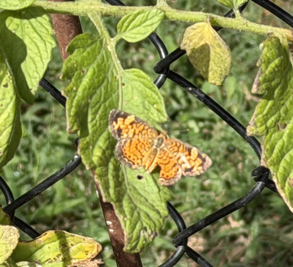
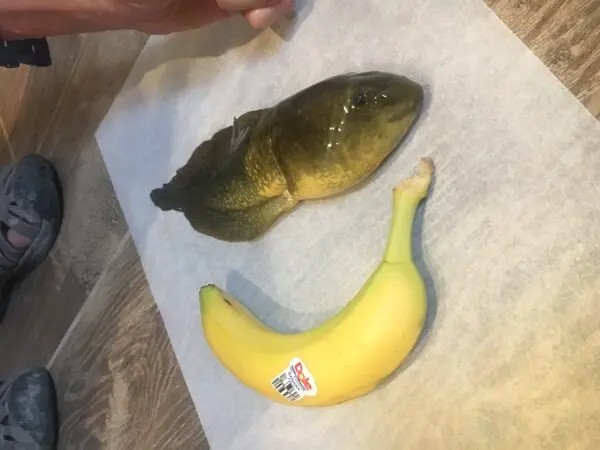
Wash

April 15, 2026

I was surprised to see how much dirt and grime accumulated on the RV while we were on the road.  The vehicle had sat outside from December to February.  While I had winterized and cleaned the interior I did not do much to the exterior.  I had purchased a cover designed to go over the unit but had been reluctant to put it on due to the time and thought of trying to accomplish this on my own (yes, I could have asked Melissa).  I thought we might go on a short trip at some point, but this did not happen.  I had taken the RV to a truck wash prior to leaving and it cost US$56.  This did not seem outlandish as it cost around US$20 for my car but it was still a lot of money.  Now that we have returned, I knew I needed to get out and clean.  I did my research and ordered the necessary tools online (I could not find them locally).  Everything arrived Monday and I was ready to wash the RV.       

When I went online, I found it best to establish an RV maintenance schedule that includes an exterior wash every 4 to 6 weeks during travel season.  Regular washing prevents the buildup of road grime, bugs, and environmental contaminants (bird droppings or tree saps) that can damage paint and seals.  Several types of washes should occur along with the standard exterior wash.  This includes a post-trip rinse to remove fresh bugs and salt from the surface.  A full detail (wash and wax) should occur 2 to 3 times a year to protect the gel coat and finish from UV rays.  The roof should be cleaned 2 to 4 times a year to prevent black streaks and allow seal inspection.  The chassis and underside should have annual washing, and an immediate wash if the RV is exposed to road salt or beach camping.  If stored outdoors and uncovered you may need to wash it more frequently to prevent oxidation, while if in a climate-controlled garage an annual cleaning may be enough.  Many owners prefer using a large ladder for safety rather than standing on the roof itself.  The RV should be washed in the shade or on a cloudy day to prevent soap leaving water spots, while using a soft-bristled brush or micro-fiber mitt to avoid scratching the delicate exterior, along with an RV-specific soap as household detergents can strip protective wax and damage seals.  This seemed like a lot of rules.

Monday turned out to be the perfect day to wash the RV as it was warm yet overcast.  I moved the vehicle onto the street to allow the gutter to whisk away the water rather than creating a mud puddle in my yard.  I had watched enough YouTube videos to know I needed to start with the roof and then work my way down to avoid streaks (one saying, “Wash your RV in minutes rather than hours”).  I have acquired several ladders and thought that might be the best way to clean.  Two were too short and the third was so unwieldy it made it hard to maneuver the brushes.  I had checked the capacity rating for our fiberglass roof and found it could easily hold me.  The problem was climbing the small ladder on the rear to get onto the roof and then figuring out how to wash the front.  I finally overcame my vertigo and climbed onto the back of the roof.  The brush setup had a 20-foot (6 m) extension and after much trial and error I was finally able to clean the roof.  Cleaning the sides and front were simpler as I was firmly on the ground.  None of this was hard, merely time-consuming.

THOUGHTS: It took me over four hours (lunch included) to wash the RV.  The quick video included a power washer which other postings warned about (strips the decals and paint).  I was amazed how much grime came off and Melissa commented on how clean the RV looked.  I think my established schedule will include trips to the truck wash along with my hand detailing.  While I do not look forward to these washes, it will keep our exterior looking fresh and new for more years.  My grandfather used to say you can tell how good a farmer is by how they keep their yard.  The same is probably true for an RVer.  Act for all.  Change is coming and it starts with you.

Shellear

April 09, 2026

Inside the back section of my local newspaper was a Reuters article about 1000’s of small fish in Africa climbing up a 50-foot (15 m) waterfall.  A researcher from the Université de Lubumbashi in the Democratic Republic of Congo first discovered them 17 years ago at Luvilombo Falls, a waterfall in the south.  Pacifique Kiwele Mutambala, another researcher from the same institution, made the trek to the falls between 2018 and 2020 determined to document this African fish.  Mutambala witnessed the epic climb but lost all his evidence.  The fish had not been scientifically documented until a study was just published in Scientific Reports, with Mutambala as one of the lead authors.  Locals have known about this fish for at least 50 years.  In the local Sanga language, the shellear is called “kalumba,” which derives from a verb meaning “to stick.”

When I went online, I found the Parkouring shellear (Parakneria thysi) will spend hours crawling up a waterfall’s cliffside to reach better habitats.  These tiny fish are about 1.4 to 1.9 inches (3.5 cm to 4.8 cm) long.  The fish are remarkable for their endurance and adaptability, as they scale the cliff faces against strong water currents.  To move upward, the shellear use hook-like growths on the undersides of their pectoral and pelvic fins to grip the rock, then rock their tails side-to-side to generate extra momentum.  The climbing mostly happens between April and May (end of rainy season) when they move to better habitats.  Scaling the cliff takes about 9 hours 45 minutes on average to climb the 50-foot-high cliffside of Luvilombo Falls.  This is further broken down into about 15 minutes of active moment, 30 minutes of brief pauses, and nine one-hour respites.  The process is not always successful as a sudden jet of water can knock them off, forcing them to restart the climb.

Biologists have several theories why the Shellear may attempt these excursions after hard rains wash them downstream. This may be a way for the fish to reach locations with less food competition and fewer predators like the silver butter catfish (Schilbe intermedius).  Regardless of the reason, the climbing the waterfall makes the shellear susceptible to illegal fishing tactics.  The area is at even greater risk of biodiversity loss due to potential plans to divert the river upstream to irrigate crops during the dry season.  The shellear population could disappear entirely if conservation efforts in the Upemba National Park lose support.  The study’s authors hope a better understanding of the fish will highlight both the region’s incredible ecosystems, as well as the need to protect them.

THOUGHTS: While the Parkouring shellear is the first scientifically documented African species to climb waterfalls, other fish species around the world have evolved similar abilities to scale vertical rock faces.  In South America, several species in the order Characiformes (e.g., certain Corydoras catfish) and order Cichliformes (e.g., some cichlids) have been observed climbing waterfalls in the Amazon and Orinoco basins.  These fish use similar fin structures and body movements to grip and propel themselves upward.  In Southeast Asia, species such as the Asian climbing perch (Anabas testudineus) and certain mudskipper (Family, Oxudercidae) relatives can climb onto mudbanks or rocky substrates, though not always vertical waterfalls.  Finally, Australian lungfish (Neoceratodus forsteri), and mudskippers have been documented moving over rocky surfaces, though their climbing is more horizontal or bank based.  It seems the more humans research the more diverse our fellow Earth travelers are found to be.  Unless we protect and preserve the fragile ecosystems where they reside, knowledge of their diversity will be lost.  Act for all.  Change is coming and it starts with you.

Monarch Pass

April 04, 2026

Our return from Utah took Melissa and I along the southern route through Colorado to avoid having to drive the steep passes of the central Rocky Mountains.  Melissa drove the 13 miles (21 km) of 6% grade on I-17 that drops into the Verde Valley and neither of us were excited about a repeat.  Things began as we took US Highway 50 out of Grand Junction, encountering rolling hills but nothing we could not handle.  Then we saw a sign that said Blue Mesa Summit (elevation 8,704 feet or 2,653 m) was just ahead.  The pass divides the watersheds of Little Cimarron River to the west and Blue Creek to the east.  This stretch is approximately 12 to 15 miles (19 to 24 km) long and has sections with grades of 6 to 10%.  Having ridden Verde Valley the previous week I was prepared for Blue Mesa and drove through without much concern.  I assumed we had made it through the lower Rockies, and I breathed a sigh of relief.  Little did I know looming 50 miles (80 km) ahead was Monarch Pass. 

When I went online, I found Monarch Pass (elevation 11,312 feet / 3,448 m) is a high mountain pass in the Rocky Mountains of central Colorado, US.  The pass is located on the Continental Divide of the western US at the southern end of the Sawatch Range along the border between Gunnison and Chaffee counties, approximately 25 miles (40 km) west of the town of Salida.  The pass carries US Highway 50 over the Sawatch Range providing a route between Tomichi Creek in the upper basin of the Gunnison River on the west and the South Arkansas River on the east.  The pass can be traversed by all vehicles under most conditions and is generally open year-round.  However, 7% grades exist and the area is prone to heavy winter snowfall which often results in temporary closures during severe winter storms.  The highway does have some three-lane sections and runaway truck ramps are located about halfway down both the eastern and western sides of the pass.  Ten curves have a 35 mph (56 kph) advisory speed and one 30 mph (48 kph).  The West Descent has a 6% grade for 9 miles.  The East Descent has a 6% grade for 10 miles.

The climb up Monarch Pass begins at 8,184 feet (2494.5 m) and climbs over 3000 feet (914 m) to the summit with a steady 5-8% grade.  We were lucky enough to be traversing the eastern descent, so we got that extra mile (1.6 km) of steep grade.  Monarch Pass is rated as the #19 most feared road to drive in the US, especially during the winter due to heavy snowfall, strong winds, and several known avalanche areas.  The steep grades and sharp curves combine with a lack of shoulder or guard rails to make this route particularly hazardous.  As we neared the summit, we saw signs for “active snow removal” ahead.  The summit was covered in snow (thankfully not on the road) and a dense fog set in.  I did not know if that might be better as I could not see the drive awaiting us.  The fog lifted as we descended and Melissa looked out the side window into the 300 foot (91 m) drop to the trees below.  She kept her eyes directly ahead for the rest of the descent.  We crept down the mountain, only periodically applying the brakes.  A harrowing 25 minutes later we were down.

THOUGHTS: After Monarch Pass Melissa told me we are never going to take US Highway 50 again.  The problem is, unless you avoid Colorado entirely you will need to take some risk to cross the Continental Divide.  I had taken all these passes without incident when driving a car.  It was vastly different in a motor home towing our Jeep.  When we tried to find the number of annual fatalities on the road the site said, “it varied”, but they did occur “periodically”.  Spending six weeks driving 5000 miles (2495 km) across much of the southern US (Arizona to Florida) gave me a new perspective on the drivers that supply the US with 72% of domestic tonnage (11 to 13 billion tons/10 to 12 m tonnes) annually, valued at more than US$13 trillion.  These trucks do not stop on a dime, so give them a break.  Act for all.  Change is coming and it starts with you.

Moab

March 25, 2026

I moved to Salt Lake City in 1979 to attend graduate school.  I grew up in Kansas (various), and was used to living in towns surrounded by agricultural fields or the remnants of the big bluestem (Andropogon gerardi) that dominated the tall grass prairie.  What I found in Salt Lake was the Uinta Mountains on one side and a salt desert on the other.  While I quickly adapted to the mountains (skiing) I did not like the desert, finding it hot, salty, and barren.  After a few years I was drawn to the archeological sites of the four corners region and southeastern Utah (Anasazi cliff dwellings).  I later worked for the Division of State History mapping and encoding sites and participated in several archeological surveys in the area.  The more I worked in the area the more I was drawn to it.  By the time I left for California I found it was the desert I missed the most.  The largest city in the area at that time was the declining town of Moab with 4000 people.   

When I went online, I found Moab is the largest city and county seat of Grand County and is known for its dramatic scenery.  The population has risen from 4800 in 2010 to 5400 at the 2020 census.  Moab attracts lover 3 million tourist annually, mostly visitors to the nearby Arches (4 miles/6.5 km) and Canyonlands (22 miles/35.5 km) National Parks.  The town is also a popular base for mountain bikers who ride the extensive network of trails, including the Slickrock Trail.  Off roaders also come to for guided Jeep tours and the annual Moab Jeep Safari.  Moab has experienced a surge of second-home owners as the mild winters, and enjoyable summers attract people to the area.  This mirrors other resort towns in the American West and controversy has risen over the new residents and their houses, many of which are unoccupied most of the year.  Moab citizens are concerned the town is changing like the towns of Vail and Aspen in Colorado.  This means skyrocketing property values, a rising cost of living, and corresponding effects on local low- and middle-income workers.

I was anxious to revisit the quaint town of Moab and enjoy the solitude of the surrounding desert.  Melissa had been talking about visiting the area I loved ever since she heard stories of the many weekend trips taken by me and my son Alex.  Often, we would not see another human from the time we left the main road until we returned.  The desolation and isolation that had initially turned me off became the basis for my attraction.  What we found now was dramatically different.  Construction started several miles outside of town, with light industrial sites, gas stores, and fast-food chains.  These were interspersed with motels, residences, and RV parks.  The street was lined with businesses offering scenic tours by jeep and mountain bike.  If you did not want a tour, you could rent either to go on your own.  There were offers for ziplines along the canyon rim and plane rides.  What struck me most was the change from quiet isolation to the hundreds of people walking or biking along the main throughfare.  While the residents may be only 1500 more than I remembered, tourists overwhelmed the city.  Moab embraced the niche market of adventure tourism. 

THOUGHTS: Melissa and I camped our RV about 15 miles (24 km) north of Moab in the new (2021) Utahraptor (yes, found there) State Park.  This was centrally located to spend time at two sites I fondly remember, Dead Horse Overlook and Arches National Park.  We found Arches often has long wait lines to enter (exceeding 60 minutes from spring through fall) and the park temporarily restricts access if parking lots fill up.  We opted to go straight to Dead Horse.  Here again we found 100’s of people.  Most were hiking or mountain biking the roads and trails that wind through the park.  My recollection was seeing one or two other cars at the overlook.  While you can go home again, it may not be recognizable.  Still, the trip was worth it and the scenery spectacular!  It was worth the crowds.  Act for all.  Change is coming and it starts with you.

Burros

March 19, 2026

Several days ago, we camped in the Homolovi State Park in Winslow, Arizona.  I was excited to camp in the park as it contains the remains of two pueblos along with a petroglyph panel.  Homolovi now serves as a center of research for the late migration period of the Hopi from the 1200’s to the late 1300’s.  The park is over 4000 acres (1618.74 ha) and includes a visitor center and museum, various trails and the campground where we spent the night.  We arrived early as I wanted to explore the ruins and walk the trails.  As we entered the gated park, we saw a sign indicating it was an open range (animals roam free inside the fenced area).  We explored the partially excavated Homolovi II site and then took the kids for a walk around the parking lot.  The docent at the museum had shown me where the petroglyph (pecked rather than drawn) panel was located and that became our second stop.  On the way to the ruin, we noticed several animals grazing off in the brush.  On our return the animals had moved closer to the road, and we saw they were wild burros. 

When I went online, I found Wild burros (Equus asinus) in Arizona are primarily found in the western desert mountains, most famously in the historic mining town of Oatman, where they roam freely and interact with visitors.  The burros are descendants of 19th-century mining pack animals.  The protected animals can also be found near Lake Pleasant, near Peoria, Arizona.  While the burros are a popular attraction, they are wild.  They can bite or kick and feeding them is discouraged to protect their health and safety. The burros are often found in various Bureau of Land Management (BLM) areas in western Arizona and are particularly active during early morning and late afternoon.  There are over 10,000 estimated wild burros in Arizona, which is far above the sustainable level for the environment (less than 1,500), leading to BLM efforts to manage the population and reduce their impact on the desert.  The burros are protected under the federal Wild and Free-Roaming Horses and Burros Act (Public Law 92-195) of 1971, which means it is illegal to harass or harm them.  BLM suggests the best way to see the animals is from a distance, without pulling off the road.

While the burros we saw at Homolovi were from a distance, we found them close when we arrived at our Lake Pleasant campground.  There was a group of three who were feeding among the campers across from where we were assigned.  I had been wary of camping at several of the “Horse Motel” campgrounds set up to accommodate equestrian travelers along our route as I was unsure how the kids would react to the large animals.  Now I had no choice as we were invading their protected land.  We kept the kids inside while we set up camp and placed the night shade over the front windshield of the RV.  I checked outside before taking the kids for a walk to burn off energy before feeding them.  We all settled in together inside the RV as it was too hot to be outside.  Later that evening I put on their lease to take them out for a final trip.  I always go out before them to make sure I have control of the lease.  When I opened the door, Zena nearly knocked me down as she tore through the opening with her VERY loud protective bark.  One of the burros was standing about 15 feet (3 m) from our front door.  I do not know who was more surprised, the burro, the dogs, or me.   

THOUGHTS: While wild burros are predated by mountain lions, this is not enough to keep their population in check.  The Wild and Free-Roaming Horse and Burro Act charged BLM with managing wild burros in a thriving natural ecological balance with other plants and animals to maintain healthy ecosystems.  Wild burros removed from management areas due to overpopulation, emergency situations, or through nuisance are available for adoption through the BLM’s Wild Horse and Burro Adoption Program.  Protecting an invasive species is always a fine line.  Act for all.  Change is coming and it starts with you.

Verde Valley

March 18, 2026

After battling the winds across the Panhandle region, we were home free as we climbed into the Ponderosa pine (Pinus ponderosa) forest that surrounds Flagstaff, Arizona.   The Coconino National Forest is located within the world’s largest contiguous Ponderosa pine forest (yes, where the name Ponderosa Ranch comes from on the long-running TV series Bonanza).  These dominant, tall trees are famous for their orange-brown, puzzle-like bark that smells like butterscotch or vanilla.  We also passed three National Monuments along the route that were extant cliff dwellings of the prehistoric Ancestral Puebloans (Anasazi).  Like so many other first-time travelers to Arizona, we were surprised to find the dense forest of the Kaibab Plateau rather than the stark desert we associated with the state.  As we traveled south out of Flagstaff the forests diminished and the saguaro cactus (Carnegiea gigantea) took over as we began to drop in elevation.  The saguaro is the largest cactus in the US and acts as a vital, long-lived (up to 200 years) keystone species in the Sonoran Desert.  While I had anticipated the saguaro, I was not prepared for the Verde Valley descent.    

When I went online, I found the steep grade on Interstate 17 descending from Flagstaff toward Phoenix is often referred to as the Verde Valley grade or simply the I-17 mountain corridor.  This stretch includes a sustained 6% grade for roughly 13 miles (21 km) between Flagstaff and Camp Verde, Arizona that requires runaway truck ramps.  The stretch also includes another steep section for southbound traffic near Black Canyon City.  The route is known for high speeds, steep inclines, and sharp curves and is often cited as one of the most treacherous connections in Arizona.  While Flagstaff sits at 7000 feet (2133 m), Phoenix rests in the Verde Valley at an elevation of 1,086 feet (2133,6 m).  Although only 145 miles (233 km) apart, the great difference in elevation result in drastic climate changes.  Flagstaff is typically 20F to 25F degrees (36 C to 45C) cooler than Phoenix on any given day all year round.  This was a descent we were unprepared for.

Our first indication of the Verde Valley downgrade was a sign saying, “6% grade ahead.  Trucks and vehicles towing trailers use lower gears.”  We were driving the RV and pulling our Jeep behind.  We qualified for the warning.  My first thought was I was glad I was not driving.  Then, I wondered if I should offer to drive.  Neither of us had driven anything close to these conditions, so I was not sure I could do anything better than Melissa.  Instead of pulling over, Melissa asked for suggestions on how to drive.  She slowed down and I clicked on the emergency flashers as we began our descent.  The first thing we tried was shifting into 2nd gear.  That did not last long as the engine RPM climbed close to the red line.  I had just read an article online about the best way to slow your RV when on a steep grade and it suggested to make hard brakes followed by taking your foot off the brake.  Melissa shifted into Drive and periodically punched the brake to slow down.  There were also reprieves on the descent where it would level off or even ascend for short distances.  Melissa did a great job, and we got down without incident.

THOUGHTS: Toward the end of the Verde Valley descent, we passed a truck parked along the side of the road with its brakes smoking.  I was glad the driver was able to stop (and that we had avoided a similar situation).  I was also proud of the way Melissa had handled driving.  It was tense for me, and no doubt more so for Melissa.  I knew we had to retrace this route on our way to Utah, but this time we will be going up, a whole new set of problems.  This last month has been an amazing immersion into the diversity of the US.  We traveled from the Ozarks to the Florida Atlantic coast, then to the high plateau and desert of Arizona.  The people have been just as diverse.  Rather than a detriment, diversity is what defines our nation.  Act for all.  Change is coming and it starts with you.

JL

February 26, 2026

A lot has happened since we set out on our first long distance RV trip last week.  We spent the first night in a Love’s gas station parking lot, which was like camping in a parking lot (because it was).  The next two nights we spent in a state park and private RV campground.  Both were nice but closer quarters than we were used to (with our vast experience, haha).  The drama started immediately.  I set up the jeep as a toad (pulled) vehicle and installed the Blue Rhino barking system.  For some reason I could not get the brake to secure.  Since the dealer was on our way out of town, we decided to stop and ask what we were doing wrong.  It turned out the “problem” was I had set the seat too close to the auto brake.  The tech moved the seat back 1/4 inch (0.3 cm) and it worked fine.   The next difficulty came as I tried to back the toad (jeep) and found when the transmission is disengaged the wheels lock in reverse.  The final drama came on the third day of driving as the brake system kept turning off.  I reset the jeep to ACC twice before giving up.  When we arrived at our campsite, I found the battery on our jeep JL was completely dead.

When I went online, I found a Jeep JL battery dies in toad mode because the vehicle’s computer systems, especially the LED taillight system, remain active and wake up periodically.  This causes a significant parasitic draw.  The battery drawdown is compounded as the ignition needs to be left in accessory mode to power the supplemental braking systems.  There are four systems that contribute to the drawdown.  First is communication with the LED Taillights as the computer constantly checks for connected lights.  LED lights have a low resistance which keeps the computer awake and drains the battery.  Leaving the ignition in Accessory (ACC) or Run mode keeps electronic components powered by using the battery.  Supplemental braking systems (like ours) can draw power from the Jeep battery if not properly set up or if they lack a dedicated charging line (ours does not).  Finally, JL’s auxiliary battery system can also cause issues.  These drained our battery.

When we disconnected the dead toad at the camp site Melissa and I were both trying to figure out how to get our Jeep JL started the following morning.  We had AAA road assistance, so we thought of calling for a jump.  We also have Good Sam assistance so we could call them as well.  The problem would be waiting for the drivers to arrive to jump the vehicle.  Then we thought we could ask the campground hosts for a jump.  I always carry cables for situations just like this (from experience).  We went to bed dreading the hassle that awaited us in the morning.  During the night, I had an epiphany.  While the toad may have been drained, the RV was not.  I unhooked the toad, turned the RV around, and applied the jump.  The jeep fired up and we were ready to go.  However, we were still 200 miles (322 km) from our destination.  Melissa decided to drive the Jeep to our next destination to maintain the charge and avoid the drawdown. 

THOUGHTS: Now that we knew what was causing the problem with our JL, we needed to figure out how to fix it.  We could install a 12-volt charge line from the RV to keep the battery charged, install a wiring harness that disconnects the Jeep’s lights from the computer, or install a battery disconnect switch.  I asked our RV mechanic if I could do any of these and he said, “probably not” (he knows me too well).  You could also just make sure the ignition is off (not in ACC) after setting the transfer case to neutral, but this will not allow the brake system to operate.  We decided to Jerry-rig the system by running the engine every time we stopped.  “Jerry-rigging” refers to a makeshift, temporary repair, and originates from 18th-century nautical terminology where a “jury mast” was a temporary mast.  Bailing wire and duct tape do wonders, but you ultimately need to get things fixed right.  That is also true for relationships.  Act for all.  Change is coming and it starts with you.

Locator

February 11, 2026

Yesterday began as a normal day.  I drove into town to visit some friends and then decided to do some shopping.  We are preparing for a trip in our RV and I needed dog food.  While the little man will eat anything you put in front of him (he loves the crunch of carrots), our big girl is sort of picky about what she eats (no carrots!).  The store has a quality brand that is much cheaper than either the pet store we used to shop at or even online.  I have also started using their phone app that allows me to scan my purchases and skip the register   Since I was picking up several items (the alure of the box store) I placed my phone in the baskets to easily scan my items.  When I was done, I swiped the payment, put my phone back in the cart, and proceeded to the exit gate.  The woman at the door waved me through and I walked out to the parking lot.  That was where the trouble began.  I had forgotten where I had parked in the large lot.  I walked up and down several rows of cars and did not see my Jeep anywhere (come on, I know you have done this).  The vehicle does have a locator attachment geared to my phone, but it was not specific enough to pinpoint other than the right lot.

When I went online, I found Locator tags (or Bluetooth trackers) are small battery-powered devices that attach to personal items (keys, wallets, luggage, pets) to track their location.  Tracking can be done using smartphone apps via Bluetooth or from wider crowdsourced networks (e.g., Apple Find My, Android’s Find My Device).  Leading options are equipped with features like sound alerts, last-known location mapping, and, in some cases, precision finding.  AirTags use the extensive Apple network, while Tile relies on the Life360 network, and Samsung trackers use the SmartThings Find network.  Certain models (AirTag and SmartTag2) use Ultra-Wideband (UWB) technology to guide you directly to the item with on-screen arrows.  Many locator tags can play a loud sound to help locate items and will send alerts if the item is left behind.

Since the locator tag for my app was not specific, I started clicking the “open” button on my car keys to see if the taillights appeared anywhere close.  They were not.  In desperation, I finally hit the panic button.  The alarm went off and indicated the car was in the opposite direction to where I had been searching.  I moved toward this section of the lot and hit the alarm again.  There was my vehicle, right where I had left it.  I stowed on items in the Jeep, put up my cart, and proceeded to my next shopping destination.  As I exited that store, I happened to check my pants for my phone.  It was not there.  I franticly search the car.  It was not there.  I realized I had left my phone in the basket at the box store.  I hurried back and saw the carts had been taken back inside the store.  I asked the two young men standing outside if they had seen my phone.  They had not but suggested I check at the customer service inside.  I approached the service desk and asked if anyone had turned in a phone.  The woman asked me what color it was and after handing me the phone asked me to open it (to make sure it was mine).  The phone opened and she told me to “have a nice day”.  I finally could.    

THOUGHTS: After my two mishaps yesterday, I was grateful for having locator apps on my belongings.  I use them on my car keys, my luggage, my phone, and my vehicles (sort of), as well as several personal items.  I admit I got tags after losing my key fob at the lake while walking the kids.  One US$350 mistake more than makes up for the price (4 for US$20) of the locators.  While I have yet to again lose anything, my peace of mind is worth the cost.  I have even shared the locators with melissa so she can help find things.  The irony of losing my phone was I needed a phone to call to track the locator tags.  Lucky for me the one who found my phone was a good Samaritan and turned it in.  It reminded me to also do the same and gave me hope for humanity.  Act for all.  Change is coming and it starts with you.

Bustards

January 30, 2026

WAY down on my MSN browser I came across an article on an invasive species that is disrupting the fragile ecosystem of the Desert National Park (DNP) in Rajasthan, a state in northwest India.  Hybrid pigs, from wild boar (Sus scrofa) and domestic pig (Sus domesticus), appeared in the park after a canal project brought in permanent water sources and crops, turning the arid desert into a pig haven.  In the past two decades the invasive species have become opportunistic predators and competitors endangering local plants and animals.  Manas Shukla, a wildlife researcher at the DNP, said, “The invasive pigs are becoming a major competitor of threatened vulture populations over food that can further impact these declining species.”  Farmers have reported crop damage, attacks on livestock, and even humans.  Bustards (Family, Otididae) and vultures (Family, Accipitridae) are also at risk, as the pigs eat the eggs of ground-nesting birds and the carcasses eaten by the scavengers.

When I went online, I found Bustards are a family of large, terrestrial birds living mainly in dry grasslands and steppe regions.  The word bustard comes from the Old French “bistarda”.  The naturalist William Turner listed the English spelling as both “bustard” and “bistard” in 1544.  All the common names are derived from Latin avis tarda or aves tardas given by Pliny the Elder.  The word tarda comes from tardus (Latin, “slow” and “deliberate”), which aptly describes the species’ typical walking style.  The two largest species of bustards, the kori bustard (Ardeotis kori) and the great bustard (Otis tarda), are frequently cited as the world’s heaviest flying birds.  Males can exceed 44 pounds (20 kg), and average around 30 pounds (13.5 kg), with a length of 59 inches (150 cm).  The smallest species is the brown bustard (Eupodotis humilis), which is 16 inches (40 cm) long and averages 1.3 pounds (600 g).  Bustards are among the most sexually dimorphic groups of birds with males often 30% longer and sometimes more than twice the weight of females.  Bustards are omnivorous and opportunistic, eating leaves, buds, seeds, fruit, small vertebrates, and invertebrates.

Forest officials have removed the pigs from bustard enclosures but have yet to enforce large-scale control measures due to wildlife protection laws.  Researchers argue that the invasive pigs are not native wildlife and should be controlled or translocated to protect the local ecosystem.  Human intervention, like building infrastructure or bringing in artificial water sources, changes ecosystems to unintentionally favor invasive animals.  Native populations decline because the ecosystems have changed and allowed invasive species to proliferate.  About 2 in 5 threatened or endangered species are at risk due to invasive species, according to the National Wildlife Federation.  Invaders bring harm by outcompeting, preying on, and spreading diseases, along with disrupting food chains, and destroying habitats.

THOUGHTS: Like the threat to the Bustards, human activity can bring invasive species to new environments.  Travel and trade transport species but changing land use can also allow them to move and prosper.  Converting land for agricultural use opens it to exploitation from invasive species.  The United Nations shared that human activity has already altered approximately 70% of the world’s ice-free land, and often in ways that unintentionally reshape local habitats.  Many of the world’s creation stories place humans as the caretakers of the world rather than exploiters of its resources.  Ignorance (or apathy) can no longer be an excuse for destruction of the environment.  Act for all.  Change is coming and it starts with you.

Tortoise

December 24, 2025

Inside Monday’s newspaper was a USA Today article on a dog being trained to help with relocation of a threatened species in Florida.  Gerry-Anna Jones, a trainer at Goldstar Puppy Academy in Fort Pierce, is training Echo, a 3-year-old male husky-shepherd mix, to sniff out a small fake scented shell so the reptiles can be moved and protected before their habitat is developed.  Florida’s building boom is having a disastrous effect on the reptiles which are a 60-million-year-old keystone species whose burrow provides food and habitat for about 365 species of bugs, reptiles, rodents and other mammals.  Before 2007, developers could bury them alive, which suffocated or starved them.  Since being deemed a threatened species, they must be relocated.  Relocations have increased 358% on the Treasure Coast from 178 in 2014 to 816 in 2021, compared to 66% in Florida from 6,730 in 2014 to 11,171 in 2021, according to Neal Halstead, research director and lead instructor in the authorized gopher tortoise relocation agent training program at the nonprofit Wildlands Conservation.

When I went online, I found the gopher tortoise (Gopherus polyphemus) is a species of tortoise in the family Testudinidae native to the southeastern US.  The genus Gopherus contains only tortoise’s native to North America.  The species has forefeet well adapted for burrowing, and elephantine (stocky) hind feet, a feature common to most tortoises.  The front legs have scales to protect the tortoise while burrowing.  Individuals are dark brown to gray-black in color, with a yellow bottom shell (plastron).  A projection on the throat (gular) is evident on the front (anterior) plastron where the head projects from the shell.  The female has a flat plastron while the male has a concave plastron that is generally longer than the female.  The adult upper section of the shell (carapace) length ranges from 6 to 11 inches (15 to 28 cm), with a maximum of 16 inches (41 cm), and is at least twice as long as it is high.  Body mass averages 8.8 pounds (4 kg), with a range of 4.4 to 13.2 pounds (2–6 kg).  They are the only extant species of the genus Gopherus found east of the Mississippi River.  The IUCN Red List of Threatened Species lists the gopher tortoise as “vulnerable”, primarily because of habitat degradation.  The animals are considered threatened in some states while they are endangered in others.  The gopher tortoise is the state reptile of Georgia and the state tortoise of Florida.

Jones is working with Echo to switch from scent samples to live tortoises now that he knows his job, with a goal to have Echo ready for field work by spring 2026.  “He has been able to pick up the scent,” Jones said, “This morning (December 18), he hit on a burrow.”  She trains Echo to zigzag through the landscape until he smells a live tortoise.  After pinpointing a location, Echo will lie down next to a tortoise or its burrow.  Handlers will work with a registered gopher tortoise agent or researcher to collect data and move the animal to a permitted recipient site if needed.  At the recipient site, the tortoise ideally will become habituated to its new home range over several months to prevent the tortoises from homing back to their old burrow.  Jones believes the collaboration between the Goldstar Academy and Gopher Tortoise Alliance is a major step toward conservation.

THOUGHTS: While Echo is being trained to find the gopher tortoise, other dogs are being trained to locate other species.  Dogs are used in surveys with the Mojave Desert Tortoise (Gopherus agassizii) prior to construction to protect critical habitat.  Dogs find Eastern Box Turtles (Terrapene carolina carolina) to aid research on reptile diseases by the St. Louis Zoo.  Dogs located the

once-thought-extinct western pond turtle (Actinemys marmorata) in California’s Golden Gate National Recreation Area.  I was impressed that the kids were able to determine which hand their treat was in!  The association between wolves and hunter–gatherers began 17,500 years ago and they are the only domesticated large carnivore.  Act for all.  Change is coming and it starts with you.