Canyon

May 29, 2026

Getty Image

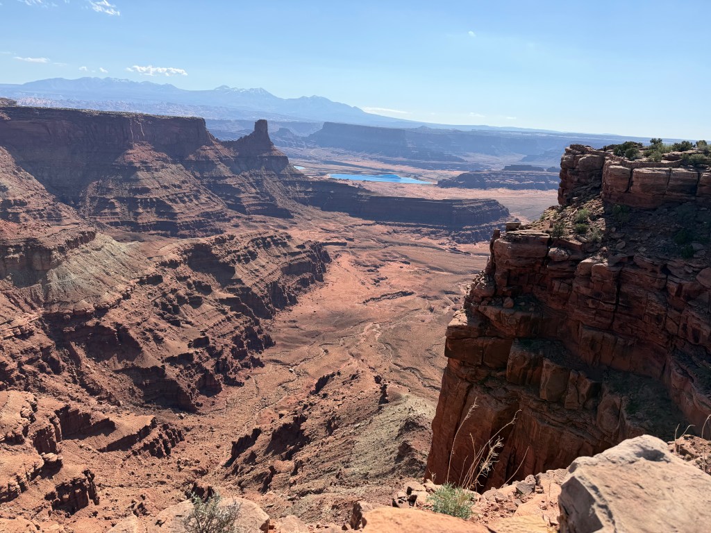
Melissa and I took two long trips this Spring in the RV.  We took two trips last Fall to begin RVing.  Both trips were less than 100 miles (161 km) and consisted of three days during the middle of the week.  We did not pull a vehicle (“toad”) on the first trip and any missed items we went without.  We towed the Jeep the second time and were able go into town pick up needed items, including a hose extension for water.  We thought we had worked out the kinks and left in February on a 1100-mile (1770 km), 2-1/2 week trip to Florida, but struggled keeping the toad battery charged and had to buy a sewer extension.  We thought we solved the battery issue during the week home before we left in March for a 1200-mile (1931 km), 3-week trip to Arizona.  We did not.  Every time we left the toad attached overnight it still ran down the battery.  To top it off, the city water connection valve stripped and we could not connect to the camp hoses.  We had planned on stopping at the Grand Canyon, but our main sights were set on my old stomping ground in Utah, so we powered on by.

When I went online, I found a canyon forms by a combination of flowing water, tectonic uplift, and weather acting on the earth’s surface over millions of years.  The process of canyon formation often begins with downcutting as rivers and streams carve deep, steep-sided valleys into the earth’s bedrock.  The rushing water uses gravel, sand, and rocks it carries like liquid sandpaper to grind away the rock beneath its flow.  For massive, deep canyons to form, the ground beneath the river must be pushed upward by shifting tectonic plates (tectonic uplift).  This uplift makes the river steeper, increasing its speed and cutting power.  Weathering and erosion are the third force acting to create a canyon.  Rainwater seeps into cracks in the rock, where it freezes, expands, and breaks the rock apart.  Wind, flash floods, and rockslides further widen the canyon walls and wash the debris downstream, preventing the valley from simply becoming a flat slope.  All three processes occur simultaneously, and when you add the dimension of time you get a canyon.

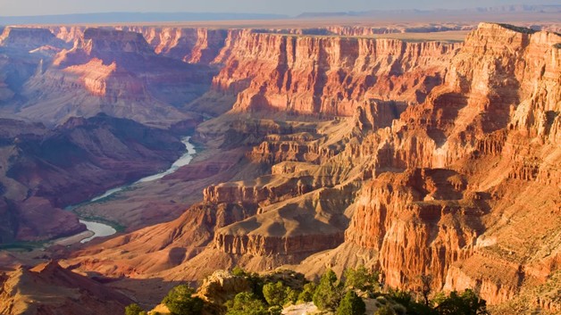
It was appropriate that after missing a tour of the Grand Canyon that an article on how it was formed appeared in a USA Today article in our local newspaper several weeks after we returned.  A study published April 16 in the journal Science provides one answer to the mystery.  According to the study, the Colorado River did not always flow through the canyon and instead began to carve its path around 5.6 million years ago after an ancient lake overflowed.  Ryan Crow, co-author and researcher with the US Geological Survey, said scientists have known the river existed 11 million years ago in western Colorado and that it did not exit through the Grand Canyon until after 5.6 million years ago.  The mystery was where did it go?  Crow said the study tested the idea that the river flowed into the Bidahochi basin in northeastern Arizona.  Sand deposits in the ancient lake showed a clear Colorado River signature, indicating the river flowed into the lake.  As the lake rose, a spillover became the primary process that established the river’s course through the (emerging) canyon.  About two million years later the lake no longer existed and the Colorado River system was fully born. 

THOUGHTS: My son and I went to the south rim of the Grand Canyon when he was a child.  We did not take the day long hike/mule ride to the bottom but were able to peer into its massive depths.  Our takeaway from our two RV trips was that we needed to be more leisurely when we travel.  We missed quite a few historic/archeological features because we felt pressed to reach our reserved campground.  We assumed if we did not reserve sites, we would not have a place to stay.  While that was true for the state parks, every commercial park where we stayed had open spaces.  In Europe we took time to “see stuff”, but at home we did not.  Do not regret taking time to enjoy the wonder of where you are.  Act for all.  Change will come and it starts with you.

Moab

March 25, 2026

I moved to Salt Lake City in 1979 to attend graduate school.  I grew up in Kansas (various), and was used to living in towns surrounded by agricultural fields or the remnants of the big bluestem (Andropogon gerardi) that dominated the tall grass prairie.  What I found in Salt Lake was the Uinta Mountains on one side and a salt desert on the other.  While I quickly adapted to the mountains (skiing) I did not like the desert, finding it hot, salty, and barren.  After a few years I was drawn to the archeological sites of the four corners region and southeastern Utah (Anasazi cliff dwellings).  I later worked for the Division of State History mapping and encoding sites and participated in several archeological surveys in the area.  The more I worked in the area the more I was drawn to it.  By the time I left for California I found it was the desert I missed the most.  The largest city in the area at that time was the declining town of Moab with 4000 people.   

When I went online, I found Moab is the largest city and county seat of Grand County and is known for its dramatic scenery.  The population has risen from 4800 in 2010 to 5400 at the 2020 census.  Moab attracts lover 3 million tourist annually, mostly visitors to the nearby Arches (4 miles/6.5 km) and Canyonlands (22 miles/35.5 km) National Parks.  The town is also a popular base for mountain bikers who ride the extensive network of trails, including the Slickrock Trail.  Off roaders also come to for guided Jeep tours and the annual Moab Jeep Safari.  Moab has experienced a surge of second-home owners as the mild winters, and enjoyable summers attract people to the area.  This mirrors other resort towns in the American West and controversy has risen over the new residents and their houses, many of which are unoccupied most of the year.  Moab citizens are concerned the town is changing like the towns of Vail and Aspen in Colorado.  This means skyrocketing property values, a rising cost of living, and corresponding effects on local low- and middle-income workers.

I was anxious to revisit the quaint town of Moab and enjoy the solitude of the surrounding desert.  Melissa had been talking about visiting the area I loved ever since she heard stories of the many weekend trips taken by me and my son Alex.  Often, we would not see another human from the time we left the main road until we returned.  The desolation and isolation that had initially turned me off became the basis for my attraction.  What we found now was dramatically different.  Construction started several miles outside of town, with light industrial sites, gas stores, and fast-food chains.  These were interspersed with motels, residences, and RV parks.  The street was lined with businesses offering scenic tours by jeep and mountain bike.  If you did not want a tour, you could rent either to go on your own.  There were offers for ziplines along the canyon rim and plane rides.  What struck me most was the change from quiet isolation to the hundreds of people walking or biking along the main throughfare.  While the residents may be only 1500 more than I remembered, tourists overwhelmed the city.  Moab embraced the niche market of adventure tourism. 

THOUGHTS: Melissa and I camped our RV about 15 miles (24 km) north of Moab in the new (2021) Utahraptor (yes, found there) State Park.  This was centrally located to spend time at two sites I fondly remember, Dead Horse Overlook and Arches National Park.  We found Arches often has long wait lines to enter (exceeding 60 minutes from spring through fall) and the park temporarily restricts access if parking lots fill up.  We opted to go straight to Dead Horse.  Here again we found 100’s of people.  Most were hiking or mountain biking the roads and trails that wind through the park.  My recollection was seeing one or two other cars at the overlook.  While you can go home again, it may not be recognizable.  Still, the trip was worth it and the scenery spectacular!  It was worth the crowds.  Act for all.  Change is coming and it starts with you.

Burros

March 19, 2026

Several days ago, we camped in the Homolovi State Park in Winslow, Arizona.  I was excited to camp in the park as it contains the remains of two pueblos along with a petroglyph panel.  Homolovi now serves as a center of research for the late migration period of the Hopi from the 1200’s to the late 1300’s.  The park is over 4000 acres (1618.74 ha) and includes a visitor center and museum, various trails and the campground where we spent the night.  We arrived early as I wanted to explore the ruins and walk the trails.  As we entered the gated park, we saw a sign indicating it was an open range (animals roam free inside the fenced area).  We explored the partially excavated Homolovi II site and then took the kids for a walk around the parking lot.  The docent at the museum had shown me where the petroglyph (pecked rather than drawn) panel was located and that became our second stop.  On the way to the ruin, we noticed several animals grazing off in the brush.  On our return the animals had moved closer to the road, and we saw they were wild burros. 

When I went online, I found Wild burros (Equus asinus) in Arizona are primarily found in the western desert mountains, most famously in the historic mining town of Oatman, where they roam freely and interact with visitors.  The burros are descendants of 19th-century mining pack animals.  The protected animals can also be found near Lake Pleasant, near Peoria, Arizona.  While the burros are a popular attraction, they are wild.  They can bite or kick and feeding them is discouraged to protect their health and safety. The burros are often found in various Bureau of Land Management (BLM) areas in western Arizona and are particularly active during early morning and late afternoon.  There are over 10,000 estimated wild burros in Arizona, which is far above the sustainable level for the environment (less than 1,500), leading to BLM efforts to manage the population and reduce their impact on the desert.  The burros are protected under the federal Wild and Free-Roaming Horses and Burros Act (Public Law 92-195) of 1971, which means it is illegal to harass or harm them.  BLM suggests the best way to see the animals is from a distance, without pulling off the road.

While the burros we saw at Homolovi were from a distance, we found them close when we arrived at our Lake Pleasant campground.  There was a group of three who were feeding among the campers across from where we were assigned.  I had been wary of camping at several of the “Horse Motel” campgrounds set up to accommodate equestrian travelers along our route as I was unsure how the kids would react to the large animals.  Now I had no choice as we were invading their protected land.  We kept the kids inside while we set up camp and placed the night shade over the front windshield of the RV.  I checked outside before taking the kids for a walk to burn off energy before feeding them.  We all settled in together inside the RV as it was too hot to be outside.  Later that evening I put on their lease to take them out for a final trip.  I always go out before them to make sure I have control of the lease.  When I opened the door, Zena nearly knocked me down as she tore through the opening with her VERY loud protective bark.  One of the burros was standing about 15 feet (3 m) from our front door.  I do not know who was more surprised, the burro, the dogs, or me.   

THOUGHTS: While wild burros are predated by mountain lions, this is not enough to keep their population in check.  The Wild and Free-Roaming Horse and Burro Act charged BLM with managing wild burros in a thriving natural ecological balance with other plants and animals to maintain healthy ecosystems.  Wild burros removed from management areas due to overpopulation, emergency situations, or through nuisance are available for adoption through the BLM’s Wild Horse and Burro Adoption Program.  Protecting an invasive species is always a fine line.  Act for all.  Change is coming and it starts with you.